Showing posts with label Copiapó. Show all posts

Wednesday, April 8, 2015

Rain? In the Atacama? Again?

Early one morning a decade or so ago, I stepped outside my hotel in the northern Chilean port of Antofagasta (pictured above) to notice an unexpected scent – during the night, it had rained in the world’s driest desert. It was barely a sprinkle, with traces of moisture on the pavement, but it reinforced for me the rarity of rain in the Atacama Desert (note the utterly barren hills behind downtown).

There was a far more serious reminder of that last week, as unprecedented storms hit the mid-Atacama region in and around the city of Copiapó, where a normally dry river course overflowed its banks and forced thousands to evacuate. In the coastal city of Chañaral, things were even worse and, in total, there have been 25 deaths and another 125 persons unaccounted for.

It’s been too long since I last visited the Atacama but, three years ago, I did have my own encounter with the lower Río Copiapó and vicinity. That wasn’t nearly so severe as the recent floods, but it did remind me that lack of water is not the desert’s only danger – there's little or nothing to stop or even slow the rare rush down the hillsides and through intermittent streams, which overflow their banks and undercut hillsides to create landslides. Flash floods can wash away houses, let alone vehicles and people, in towns like Taltal (pictured below), which also suffered in the recent floods.
I hope to get back to the Atacama later this year but, in the meantime, I learned that the most heavily-touristed area was relatively unaffected. A Dutch friend who owns a travel agency in San Pedro de Atacama tells me that “The first rains fell in our part of the Atacama, roads disappeared as usual, we were all complaining because of lost business and some leaking roofs. But then images started to come through from [farther south], and [it] all became relative again. I guess in the end we were lucky here: the storm could have hit anywhere between Calama and Copiapó...”

For my part, after spending most of the last two months-plus in Patagonia, I boarded a Sunday-night flight from Santiago bound for Lima, Los Angeles and San Francisco. I arrived early enough at Aeropuerto Internacional Arturo Merino Benítez to enjoy a farewell pisco sour, a panino, and a glass of old-vine Carignan at Vinum (pictured above), a welcome new wine bar in the departure area.
By the time the flight left, though, it was dark and there was no possibility of viewing the flood area from the air. I also left behind the forest fires and plumes of volcanic ash I had seen in Argentina and Chile, but at least this time there were no earthquakes in this seismically lively area.


Fortunately, I did not have to change planes in Lima and my connection from LAX to SFO was quick enough that I got home in time to watch opening day of the baseball season. That night, though, we had an unexpected rainstorm in the drought-stricken Bay Area – no floods, fortunately, but at least it left our garden refreshed.

Wednesday, May 30, 2012

For Whom the Toll Beeps (Or, Playing TAG in Santiago)

In California, where I spend most of the year, toll roads are anathema. We do have plenty of bridges that collect tolls, but there’s a reason that many of our highways are, for better or worse, misleadingly called “freeways” (we pay for them but, except for the bridges, we don’t usually pay directly out of pocket to use them).
It’s different in Chile, where the Panamericana from La Serena south to Puerto Montt – a distance of roughly 1,500 km – has 15 toll plazas that exact a total of nearly 35,000 pesos (about US$70) from anybody who drives the distance. That’s not counting the cost of driving through Santiago, which is a little more complicated.

That’s because Santiago has its own electronic toll system that requires anyone who drives those roads to pay a distance-based rate that varies according to the time of day, with the morning and evening rush hours the costliest. Santiago drivers have gotten accustomed to the so-called TAG or Televía system and most, like me, have an electronic transponder that registers the tolls automatically. It can be confusing, though, to drivers from other parts of the country and especially those from outside the country, such as Argentines who frequently travel to Chile.

The TAG is not obligatory, but paying the toll is, even if you don’t have a transponder. Relatively few people outside Santiago do, and some of them go out of their way, when visiting the capital, to use surface streets rather than the limited access highways. A friend of mine from La Serena tried this when picking up someone at the international airport but, eventually, had to pay a fine when he found the alternative route too complicated and couldn’t avoid the toll road. Cameras record the license plates of every vehicle, so enforcement is simple if sometimes slow.
For those who need to drive in the capital, there is an alternative: approaching the city limits, they can purchase a pase diario (daily pass) for 4800 pesos (a little less than US$10) at any roadside Copec Pronto convenience store. Those who fail to do so draw a fine but, even then, it’s possible to purchase the pass retroactively up to 20 days later; after three days, the cost increases to 6900 pesos (about US$14). For overseas visitors, it’s worth adding that cars rented in the capital will have a transponder to record the tolls automatically (to be incorporated in the rental cost). Those rented elsewhere may not have one, though, and you will be directly responsible for the toll.


While Chilean vehicles may not be able to escape the Santiago tolls, foreign vehicles might. It wouldn’t surprise me if many Argentine drivers, either unaware or evasive, use the city’s highways without paying. If they get stopped by the Carabineros police, though, they could be in trouble.

The Panamericana is not Chile’s only toll road. There are others from Santiago to the port cities of Valparaiso and San Antonio, and between Chillán and Concepción. There’s also a new four-lane divided segment connecting the Atacama desert cities of Vallenar, Copiapó, and Caldera.

Let’s Choose (Moon) Patagonia! (Update)
To date, I’ve had only one correct answer on my geography quiz from the previous post, asking readers to name the Chilean volcano that affected travel to Argentine Patagonia prior to the 2011 eruption of Puyehue. Because of that, I’ll add a couple clues – the eruption in question took place in 2008, and required the evacuation of its namesake village.
If nobody else comes up with a correct answer by the weekend, I’ll postpone giving away the second copy of Moon Patagonia. Please send your answer to southerncone (at) mac.com, and not to the comment box.

Saturday, December 10, 2011

Whales of the Atacama; Plus, Patagonia Winners

Though Chile is one of the world’s most cetacean-friendly countries, the crumbling ruins of an old whaling station on the southern outskirts of Iquique are an historical reminder that commercial whaling continued here as late as 1963. A recent discovery, though, has put all this in perspective – near the coastal city of Caldera, another Atacama desert beach resort, paleontologists have discovered a graveyard of baleen and other whales dating back at least two million years.
Ironically, were it not for the tourist industry, the discovery of these fossils might have taken decades or even centuries more. That’s because Caldera is the beach getaway for the regional capital of Copiapó, about 80 km to the southeast, and has been since 1851, when Chile’s first railroad connected the two towns. The train last ran in 1961, but a project to widen the narrow Ruta 5, the Panamerican highway that replaced it, recently unearthed remains of the whales. So far, according to researchers from Caldera’s own paleontological museum and the Smithsonian Institution, about 75 whale skeletons have been uncovered, more than 20 of them in perfect condition.

Much research remains to be done, but South America’s west coast is one of the world’s most tectonically active areas. So far, speculation is that a landslide or seismic event isolated a shallow lagoon and that, unable to return to the ocean, the animals died in situ. The lagoon then filled with sediments and, eventually, plate tectonics lifted the fossilized remains to their present hilltop location, half a mile inland.

I haven’t visited Caldera since I last updated Moon Handbooks Chile, a couple years ago, but this extraordinary discovery has me looking forward to my return there in March.

We Have Two Winners!
In the spirit of the holiday season, even though I’d rather be in the vastness of the Atacama, I decided to give away two copies, rather than one, of the new third edition of Moon Handbooks Patagonia to readers who answered Wednesday’s quiz correctly. I had a couple more correct answers as well, but I had to draw the line somewhere.
Both Suzan Apaydin of San Miguel de Allende, Mexico, and Eric Curtis of Kealakekua, Hawaii, correctly identified the wool industry as the source of Patagonia’s economic boom of the late 19th and early 20th centuries. Many of the region’s sprawling sheep farms, known as estancias, still exist today, as do the mansions of Punta Arenas, then southernmost Patagonia’s de facto capital during the wool boom.
To families like the Menéndez dynasty, who built their fortunes on exports that built mansions like the one above and tombs like the one below, the international border meant little – just as it may to the residents of Argentina’s Tierra del Fuego and Chile’s Magallanes region with the new “free movement of peoples” initiative.
I hope Suzan and Eric will be able to make good use of their books; for those whose answers arrived too late, and other readers, keep an eye for future quizzes.

Help Support Southern Cone Travel
If you have found this article useful or informative, please consider clicking on one or more of the AdSense links that accompany it - always presuming, of course, that it's a product of service that interests you. Also have a look at the Visit Britain video in the sidebar (you have to click the ad to hear, in addition to seeing, Dame Judi Dench's invitation to the UK).

Friday, August 5, 2011

Big Water, Monumental Buildings & Mine Rescues

Today's entry touches on Argentina's Iguazú falls, Chile's remote Aisén region, and an important exhibition on the Chilean mine rescue of 2010.

Big Water Gets Bigger

In the indigenous Guaraní language, Iguazú means “big water” and, for anyone bound for Parque Nacional Iguazú and its magnificent Cataratas in this southern winter, that means good news and bad news. First the good news: temperatures are mild (upwards of 70° F for the next several days) and the falls are even more spectacular than usual. That’s because, thanks to heavy rainfall in the Río Iguazú’s upper drainage in Brazil, the falls are carrying 13,000 cubic meters of water per second, about eight times their normal flow of 1,500.

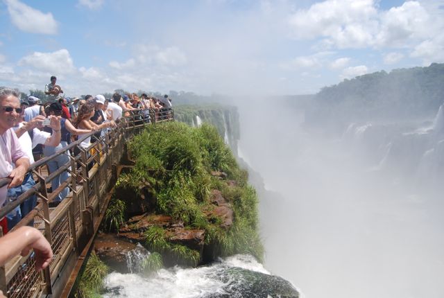
The bad news is that the flow is so heavy that national park authorities have had to close the observation deck opposite the Garganta del Diablo, the single most impressive of the nearly 300 separate falls. Even with normal runoff, the deck (pictured above) gets plenty of spray from the falls, so that visitors sometimes wear rain gear on bright sunny days.

At present, though, the increased flow makes it dangerous and slippery (nobody wants to go over the Garganta del Diablo, in a barrel or otherwise). At the same time, the excursion boats that approach the falls from below have also been suspended. With the storms ending in Brazil, Iguazú should return to normal in a few days at most.

Puerto Puyuhuapi: a Monumental Event

Much farther south, the town of Puerto Puyuhuapi, where Luisa Ludwig lives, is part of dankest Patagonia – winter gets wet and cool on the Chilean side of the Andes. August rainfall averages 401 mm (about 16 inches), but there’s a ray of sun this month - her Casa Ludwig B&B (pictured above) is the first private building to be designated a national historical monument in Chile’s southern Aisén region.

Luisa’s parents were among the 1930s Sudeten German pioneers at Puerto Puyuhuapi, which has become well-known for its custom carpet factory Alfombras de Puyuhuapi, which sends its products around the world (the photo above is one of weavers, from the island of Chiloé; the photo below is a finished product). The monument designation limits what can be done with Casa Ludwig – the exterior cannot be altered – but Luisa’s happy with the results: “Actually we asked for the declaration. We find the house beautiful as it is. And maybe it can be good publicity.”

Rescue at the Smithsonian
For those of you fortunate enough to live in Washington DC – despite the manufactured political crisis of the past several weeks, there are good things about DC, where I once spent a semester teaching at George Washington University – there’s something worth seeing starting today. With sponsorship by the Chilean embassy, the Smithsonian Institution’s Natural History Museum will host the exhibition “Against All Odds: Rescue at the Chilean Mine” as the first anniversary of the successful evacuation of the collapsed San José mine near Copiapó approaches. The Chileans, at least, can get things done; among the objects on display will be the actual rescue capsule that brought the miners to the surface (claustrophobics may want to stay away).

Help Support Southern Cone Travel
If you have found this article informative, please consider clicking on one or more of the AdSense links that accompany it - always presuming, of course, that it’s a product or service that interests you.

Thursday, October 14, 2010

Outside the Mine

Until today, I have refrained from writing anything about the miners rescued yesterday from Mina San José, on the outskirts of the northern Chilean city of Copiapó. That’s partly because the 24/7 international coverage of their plight and rescue has been so overwhelming but, on the other hand, much of that coverage hasn’t told us much about the region.
Coastal fog in the otherwise arid "Norte Chico" can support clusters of dense vegetation.
In reality, the “Norte Chico” (Lesser North), as the southern sector of the Atacama Desert is known, may be the least appreciated part of the entire country - in fact, it probably gets fewer foreign visitors than any other region. Actually, it probably gets fewer than the popular “Norte Grande” (Greater North) village of San Pedro de Atacama alone. That’s because the traditional description of “the Land of 10,000 Mines” - probably a quantitative understatement - isn’t exactly a slogan that pulls in tourists.

Nevertheless, it’s had its share of celebrity visitors, including Charles Darwin who, in the 1830s, remarked that “its produce is sufficient for only three months of the year,’ and that transportation problems raised the price of food to astonishing levels. To some degree, that’s still true, and one reason - along with risk of injury or death - why wages are often higher here than elsewhere in Chile.
The barren coastline at Parque Nacional Pan de Azúcar
Copiapó is the capital of the Third Region of Atacama, which comprises the northern half of the Norte Chico (the Fourth Region of Coquimbo, capital La Serena, gets many more visitors for its broad sandy beaches and greater proximity to Santiago). Its most appealing sight, in my opinion, is Parque Nacional Pan de Azúcar (pictured above), a seaside reserve near the mining port of Chañaral, which has abundant sandy beaches at the base of barren headlands, backed by impressive coastal mountains, but also surprisingly lush vegetations in areas where coastal fog condenses on their western slopes. It also features abundant bird life, including Humboldt penguins and brown pelicans.
Brown pelicans at Caleta Pan de Azúcar
Still, it’s the mines that have put the region on the global map, and it’s worth noting that Chile’s mines are divided between a large-scale sector with ample capital, partly but not exclusively state-run through the Codelco corporation, and a smaller sector that often cuts corners - as was the case with Mina San José. Still, it’s also a sector that pays higher wages to compensate for the dangers that working there involves. In an excellent GQ magazine article, Sean Flynn details those dangers, as well as the media frenzy that has surrounded the miners’ drama.

While there may be some quarrels with the media management of the miners’ story by the Chilean government - limiting direct access to the state-run TV Nacional and official photographers, for instance - at the end of the day, with the whole world watching, the Chileans did everything right. That’s whether or not, when the clamor dies down, the ephemeral “Campo Esperanza” (Camp Hope), which housed the miners’ families and friends just outside the mine, becomes a tourist attraction in its own right. According to the online Santiago Times, it's under consideration as a national monument.

Moon Handbooks Argentina on the Road, Again
This is a busy for digital slide presentations on the new edition of Moon Handbooks Argentina, with four events in five days. The fun starts Saturday afternoon October 16 at 5 p.m. at Travel Bug Books in Santa Fe, New Mexico, and continues Monday evening October 18 at 7 p.m. at Village Books in Bellingham, Washington. We then cross the border to Travel Bug Books (no relation) in Vancouver BC, Tuesday evening October 19 at 7 p.m., and return to Seattle, Washington for an event at Wide World Books, Wednesday October 20 at 7 p.m.
Custom Search