Buenos Aires has airport issues. That’s long been apparent, given the accessibility issues of the main international airport at Ezeiza, the problematical logistics of the urban Aeroparque and, now, a third airport in the suburb of El Palomar, used primarily for the burgeoning low-cost market.
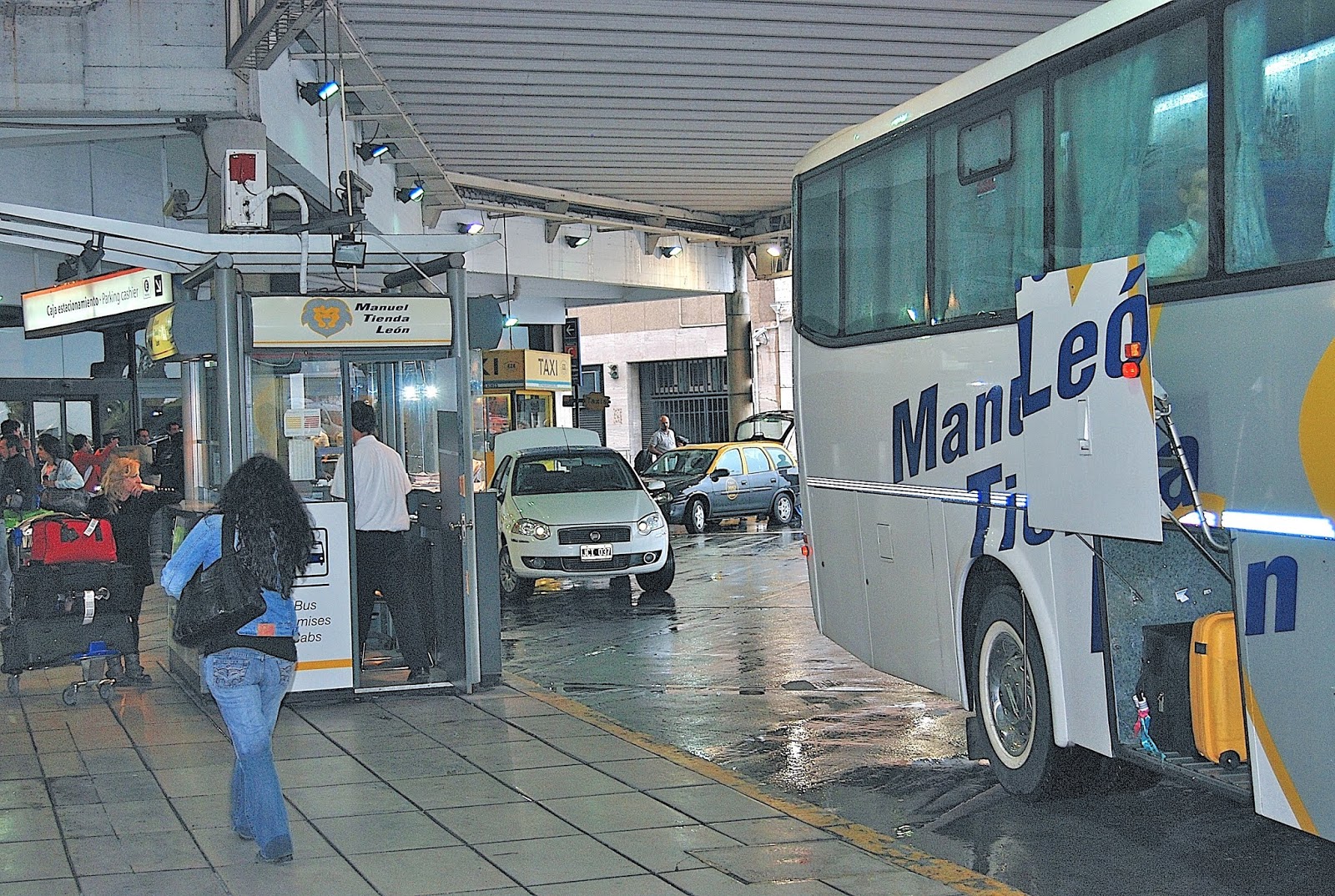
Manuel Tienda León is my default option from Ezeiza into Buenos Aires.
It’s the last of the three that I’ll be most concerned with there, but I’ll briefly mention the first two. Ezeiza, formally known as Aeropuerto Internacional Ministro Pistarini (EZE), is about 22 km south of the city center via the freeway known as the Autopista Teniente General Pablo Riccheri. That’s not far, but transportation can be problematical when suburban traffic clogs the highway at rush hour. Ideally Ezeiza would have rail service but, when I made this observation to a taxi driver, he responded that it would kill one of his main income sources (never underestimate the collective power of taxistas). When arriving at Ezeiza, I normally take the Manuel Tienda León bus/taxi combo into town—short delays don’t mean as much then—but, when leaving the country, I usually choose a cab or remise (livery car) directly there because luggage can be an issue. I still leave plenty early, though.
Aeroparque has few gates, so passengers must often take a shuttle to their plane.
Aeroparque Jorge Newbery (AEP) has different issues. It’s almost walking distance from our apartment in Palermo—or about a ten-minute cab ride—but the narrow road that runs alongside it (currently being widened by a landfill that projects into the Río de la Plata) can also get congested. Aeroparque’s biggest problem, though, is its very convenience, which brings low-flying planes to land on a crowded airfield with so few gates that passengers must often board shuttle buses for the relatively short distance to their plane. Immigration facilities also get really busy on international flights (mostly to and from neighboring countries).
Immigration gets backed up at Aeroparque.
El Palomar (EPA) is something else entirely. Only 20 km from downtown Buenos Aires, just outside the city limits, it’s a converted military airfield with only a single runway to serve FlyBondi and JetSmart, which provide cheap flights to provincial Argentine cities and to Brazil, Uruguay, Paraguay and Chile. Because of objections from neighbors, there are no nighttime flights.
The Ferroccaril San Martín is a commuter line that serves El Palomar.
On board the train to El Palomar
Getting there can be interesting. Manuel Tienda León offers remise service, but the congested approach makes public transportation a better option. The modernized Ferrocarril San Martín, a commuter line that once crossed the entire country to Mendoza, offers direct service from the central Estación Retiro, but I chose to walk from our apartment to the refurbished Estación Palermo (newly constructed overpasses have made the route quicker than it used to be). It’s 37 minutes from Retiro to El Palomar, and only 29 from Palermo, with frequencies every 15 minutes.
The gates to Aeropuerto El Palomar
This disconcerting panel stands outside the gates to Aeropuerto El Palomar.
Better yet, Estación El Palomar is barely a five-minute walk from the airport gates (presuming you’re not weighed down with heavy baggage). Some travelers may find it disconcerting, though, to be greeted by a sign that says that “This base operated as a clandestine detention center under the Air Force. According to witnesses, this was the departure point for ‘death flights’ with the purpose of killing detained and disappeared individuals from various points in the country.” During Argentina’s 1976-83 dictatorship, the military often threw sedated prisoners from planes or helicopters into the river or the open South Atlantic.
El Palomar's check-ins are congested.
After that, the terminal can’t help but be a relief, though its claustrophobic facilities are far inferior to of both Ezeiza and Aeroparque—even if conspicuous signs assure patrons that “We are modernizing El Palomar.” Not intending to fly out of there, I was unable to visit the departure areas, but I was still relieved that my own flight to Neuquén, on low-cost Norwegian Air Argentina, would depart from Aeroparque.
That scenario could change in the near future, as JetSmart has acquired Norwegian Argentina’s routes and will phase out the brand in favor of “JetSmart Argentina.” JetSmart should hold onto those gates at Aeroparque, which many if not most Porteño fliers should still find more convenient than El Palomar. That doesn’t mean, however, that I wouldn’t consider a cheap flight from El Palomar to, say, Bariloche or Ushuaia.
I’ve never been to Spain. Well I have been, I guess, if you count Catalonia as part of Spain, because I once spent a week in Barcelona. But I’ve been to Salamanca…oh, wait, not that Salamanca! Earlier this month, I spent two nights in the Chilean city of Salamanca, which I’d visited before, but this was an escape from Santiago after spending most of the previous two months in Patagonia.
Gregorio de la Fuente's "Abrazo de los Pueblos" still decorates the now disused passenger terminal of Los Andes' Ferrocarril Transandino.
How did I get to Salamanca? Well, I started slow, thanks to late-rush hour traffic out of Santiago, but then headed north to the town of Los Andes, where the Ferrocarril Transandino once carried passengers and freight across the Andean divide to Mendoza. I had no intention of visiting Argentina this time, but I did want to see the mural by Gregorio de la Fuente—his "El Abrazo de los Pueblos” (Embrace of the Peoples) at the old train station is a celebration of Argentine-Chilean friendship. It was just a brief stop, though I did learn that there’s now an occasional tourist train on this route.
Vehicles pass along the old railroad route through Túnel La Grupa, near the town of Cabildo.
Symbolically, at least, trains played a role in my route to Salamanca, as I took the paved highway west to the town of San Felipe and then north through scenic Andean foothills that resemble the higher, drier parts of Southern California. There are only scattered settlements along this route E-71, which leads to the town of Cabildo; there, a traffic light controls access through the Túnel La Grupa, one of a series of tunnels that belonged to the Longino, the Ferrocarril Longitudinal that connected La Calera (west of Santiago) to the nitrate mines and ports of the northernmost Atacama Desert.
The landscape here resembles the higher, drier areas of Southern California.
I’d driven this route before, but not for several years. In the interim, authorities have either paved—or begun to pave—much of it north of the border between Region V (Valparaíso) and Region IV (Coquimbo). This is significant because most of Coquimbo’s population resides along the coast, where cities like Los Vilos and La Serena attract beachgoers from Santiago, and this is a more adventurous (if slower) alternative to lesser-known points.
Túnel Las Palmas marks the border between the Valparaíso and Coquimbo regions.
Café Quarzo is one of few roadside services here.
There are few services on this stretch of “highway” but, surprisingly, one enterprising local has opened a small café on the northbound descent from Túnel Las Palmas, which marks the regional border. She sells ground coffee drinks—in a country where Nescafé is often still the default option—as well as juices and mineral souvenirs (hence the name Café Quarzo). The road continues, passing several railroad bridges, to the enigmatically named village of Caimanes (there are no carnivorous aquatic reptiles here, though; the name apparently comes from an indigenous Mapundungun [Mapuche] word meaning “six condors”).
Carnivorous aquatic reptiles do not populate the area around Caimanes.
Túnel Las Astas is the last of three short tunnels north of Caimanes.
The foundations of the old railroad station still stand here, but there’s no more obvious evidence until a short distance north, where the road passes through three short tunnels with no traffic lights. Several years ago, in Argentina, I met two US cyclists who’d taken this road on my guidebook recommendation and loved it, but they confessed their trepidation in riding through the narrow tunnels, with little room to dodge any oncoming vehicle. That said, this route remains a potentially great ride for adventure-seeking cyclists.
The old train station at Limáhuida is now a country store.
Emerging from the Túnel Los Astas, the road continues to Limáhuida, where the old train station is now a small market and fading wooden workshops still stand below it. That’s also where a new bridge crosses the Río Choapa and leads east to Salamanca, where I spent two nights at the modern and comfortable Hotel Recanto, on the eastern outskirts of town.
Hotel Recanto is full during the week, but nearly empty on weekends.
Oddly—or not—I was virtually the only guest in contemporary accommodations with spacious rooms, solar-powered hot water, and an outstanding restaurant. That’s because it clears out on the Thursday and Friday, as mining managers—there are large copper deposits in the area—leave for the weekend.
Farm-fresh garlic spreads at Salamanca's central plaza
Salamanca's old train station is now a museum and part of a pleasant public park.
Nevertheless, the hotel was still walking distance from a handsome central plaza with a lively crafts and farmers market, a former train station turned museum and municipal park, and easy access to nearby petroglyphs. There are also wineries in the area, though I didn’t get to visit those, but Salamanca—where I’d stayed once several years earlier, still struck me as a good weekend getaway.
The pre-Columbian petroglyphs at Cerro Chalinga are walking distance from downtown Salamanca.
It’s not the area’s only attraction, though. The next day I took the paved highway north to Combarbalá, a village which, on the face of it, resembles some Mexican villages, with narrow streets lined by adobe houses and even ranchera music. To get there, I did veer northwest off the more direct but still unpaved railroad route (though, had there been tunnels, I would have taken it again).
The fountain at Combarbalá's central plaza represents indigenous Diaguita motifs.
Mexican ranchera music is popular in rural Chile, including Combarbalá.
Small-scale mines extract combarbalita for local crafts workers.
The approach to Observatorio Cruz del Sur, in the daylight hours.
The beginning of a nighttime tour at Observatorio Cruz del Sur
Combarbalá and other nearby towns will fill up for the July 2nd eclipse.
After a night at Combarbalá, I headed the next morning for the coast, where Los Vilos would make an ideal beach break for Santiaguinos returning to Chile’s capital. For my part, I continued along the coast to Viña del Mar and Valparaíso, which will be another story here in the near future.
Buenos
Aires has its shortcomings, but one thing I’ve always appreciated is the
ready availability of public transportation. It’s still a pleasant surprise to
step onto a downtown street at 3 a.m. and wait just a few minutes for a city
bus that will take me back to my Palermo
apartment. The fare is negligible, and the buses run all night (though with
lesser frequency than they do in the daytime).
There is one exception to the rule, though, and that’s the
fact that the underground Subte (pictured
above and below) shuts down so early. In a 24-hour town – I once hyperbolized that, by
contrast, “New York is the city that takes a nap” – the quickest and most
efficient means of getting across town shuts down at 11 p.m. nightly and at 10
p.m. on Sundays and holidays. It’s almost always my first choice for getting
around town (though my Argentine wife finds underground travel disorienting and
prefers surface streets).
Those limited hours may soon change, though. Earlier this
week, city
ombudsman Alejandro Amor introduced legislation to extend the Subte’s
hours: should it take effect, the system would operate from 5:30 a.m. to 1:30
a.m. Monday through Thursday; Fridays, Saturdays and holidays to 3 a.m., and
Sundays from 7 a.m. to midnight. An accompanying press release stated that its
operating hours were among the shortest of any major city in the world – New
York, by contrast, has 24-hour service. In neighboring Chile, the Metro de Santiago
keeps somewhat longer hours than the Subte on a more extensive system.
One objection, raised by the private contractor
Metrovías and city mayor
Mauricio Macri, is that fares would have to rise to meet additional
operating expenses. The measure disputes that contention but, in any event, the
Subte’s fares are among the world’s lowest for a system of its kind. Macri, a fiscal conservative who
will be a candidate for the Argentine presidency this coming October, may
prefer not to raise fares, but it’s hard to imagine that it would cost him many
votes – city voters dislike the ruling Peronist
party faction and many would like to see longer Subte hours.
For decades now, riding Línea
A of the Buenos Aires Subte – Latin America’s oldest underground railway – has
given its regular patrons and tourists alike the sensation of riding though
history. Yesterday that became literally true, as municipal authorities shut
down the line for two months and, when it reopens, the classic wooden Brugeoise carriages
that have, served the former Compañía de Tranvias Anglo Argentina (CTAA)
will no longer operate. With minor makeovers, those carriages had operated
since 1913, so they fall just days short of a century.
According
to the Buenos Aires Herald, they comprise “70 carriages out of the original fleet … of an original
total of 120 carriages, built by La Brugeoise, Nicaise et Delcuve between 1912
and 1919 in Belgium.” On one level, that’s a pity, because their outward
solidity and the craftsmanship of their burnished wooden interiors evoked a
period when Argentina’s
future seemed bright, and the decades of political turmoil that began with the
1930 military overthrow of President Hipólito
Yrigoyen were yet unimaginable. In recent years, political conflict has
paralyzed the system, as the federal and city governments have argued over who
should operate the system, and pay for it.
Despite their picturesque patina, the historic cars had
outgrown their usefulness. They shook on the rails and, frequently, their
sliding doors would not close properly – or not at all. I’ve never heard of
anyone falling from a moving car, but it wouldn’t have surprised me. During the
suspension of service, the city government will retrain its personnel and
install electrical upgrades
to accommodate 45 new Chinese carriages; 30 others from Italy’s Fiat are
already in operation.
According to the
city daily Clarín, nostalgic Porteños overran the line
yesterday with cameras and cell phones yesterday to snap the final hours of the
historic cars, but the question remains what to do with them. Apparently, the
operators will retain some 15 cars and, presumably, some might be in good
enough condition to operate them as a tourist attraction on weekends, when
ridership is lower. That leaves another 55 or so to dispose of, and municipal
culture secretary Hernán Lombardi made an ambiguous suggestion that they could
serve as libraries in city parks – it was unclear whether he was proposing
placing intact cars in the parks or dismantling them for the wood, in order to
build new structures. In
the former case, they would probably suffer vandalism by the same tasteless
taggers who have already defaced so many of them.
Both the Subte and suburban lines, particularly the
Sarmiento, have been the victims of disinvestment that have made them
uncomfortable and even dangerous. This has been the fault of successive federal
governments that have suppressed fares at rock-bottom levels in the interest of
“social peace,” but it apparently took major fatalities to spur the current
administration into action.
At the same time, the federal government has deplored the
city’s apparent intention to raise Subte fares to 3.50 pesos, about 70 US cents
at the official exchange rate. It’s worth noting that in Chile,
where general price levels are roughly comparable to Argentina, fares on
Santiago’s immaculately maintained Metro system range from 590 to 670
pesos (roughly US$1.25 to US$1.45), depending on the time of day. If the new
Subte fares take effect, they will have tripled in a year, but they’re still a
bargain by almost any standard.
About a decade ago, in the northern Argentine city of Colón,
I encountered a pair of US cyclists who had traveled through Chile
using my recently published first edition of the Moon Handbook to that country.
They were especially enthusiastic about my recommendation about cycling the old
railroad route through the Andean foothills, where slow-moving trains from
Santiago’s Estación Mapocho once
chugged all the way to the nitrate ports of the Norte Grande, including Iquique
and Pisagua. The station, pictured below, is now a cultural center.
For motorists, bikers, and cyclists really
intent on getting off the beaten track, there’s no better alternative than the former
Ferrocarril Longitudinal (Longitudinal Railway) that, until the Panamericana
opened in the early 1950s, connected the Chilean heartland with the Norte Chico and the Norte Grande. Passing through
five former train tunnels, with countless ups and downs along the isolated
Andean foothills between La Ligua and Ovalle, the Norte Chico sector is one of
the country’s unappreciated gems for Chileans and foreigners alike.
In the 1930s, Chilean dictator (later elected
president) Carlos
Ibáñez del Campo outfitted his 1928 Packard limo (pictured above) with wheels that could ride
the rails between Santiago
and the southern city of Puerto
Montt. I’ve never done anything quite like that but, several times, I’ve
driven segments of the former northern railway, popularly known as the
“Longino.” Along the entire route, keep an eye out for condors--that enduring
symbol of the Andes reminding us that the route was, first and foremost, an Inka road.
Last April, for the first time, I drove the Longino’s
Norte Chico segment north to south (rather than south to north), from the
weathering foundations of former station at Auco, near the city of Illapel, to the town of Cabildo – a full day’s
drive. At Auco, a bridge (pictured above) still spans the normally dry bed of the Río Illapel, but walking
across it requires caution, as it’s missing many ties.
At Limáhuida (about 20 km south of Illapel),
the line’s oldest surviving station (pictured above) is now a small grocery. Along the route,
huasos in their characteristic flat-brimmed chupallas (sombreros) are a regular
sight, as are flocks of goats on the dry hillsides. Between Limáhuida and the
oddly named town of Caimanes (there are no large aquatic reptiles in this
desert landscape), the road passes through three tunnels; the longest is the
Túnel las Astas (pictured below), dating from 1912, whose ceilings drip with groundwater. Its
length makes it the likeliest in which to encounter a vehicle heading the other
direction.
Perhaps the most scenic segment is Cuesta las Palmas, about
20 kilometers south of Caimanes, passing newly planted avocado and citrus
orchards. At the regional border, the gravel road penetrates the Túnel las Palmas,
surrounded by mature palm trees in the valley, and continues as a paved road
toward Pedegua and Cabildo. A short distance north of the tunnel, a roadside
café selling fresh juices is one of few businesses catering to the handful of
travelers who pass this way.
Approaching Cabildo, a semaphore regulates
traffic through the Túnel las Grupas (pictured below), the only tunnel located in a populated
area. From Cabildo, there are paved highways west toward the coast and south to
Santiago.



_6.jpg)
.jpg)


