Showing posts with label Parque Nacional Villarrica. Show all posts

Thursday, July 11, 2019

This Year's Eclipse (and Next Year's?)

Chilean eclipse-chasers filled the beach at Caleta Los Hornos (photo by Marializ Maldonado)
I couldn’t attend last week’s solar eclipse in Chile but, indirectly at least, I had a sort of presence. When my longtime friend Marializ Maldonado, at whose house I often stay when in Santiago, asked to borrow my car to drive north to the Coquimbo region, I immediately said yes, and she was able to view the event at the beachside locale of Caleta Los Hornos, north of the city of La Serena.
In the minutes before totality, at Caleta Los Hornos (photo by Marializ Maldonado)
Partly, this was a favor to a friend, but it was also a favor to me, as it’s best not to leave a car unused for months, as I do by necessity in the outskirts of Santiago. Marializ also often does me the favor of paying my highway tolls as, for some incomprehensible reason, Chile’s online payment system does not want to accept my US credit cards (though I use them regularly when I visit Chile).
The Coquimbo region is home to major international observatories such as Cerro Tololo (CTIO), part of the US National Optical Astronomy Observatory.
Marializ arrived just five minutes before totality, which she described as “two intense and beautiful minutes” on the Pacific shoreline. The most vivid account I’ve read, though, came from the New York Times, whose “52 Places” columnist Sebastian Modak saw the event from the European Southern Observatory at La Silla—also pointing out that this was only the third eclipse to pass over a major international observatory in the last 50 years.

The eclipse turned out to be an economic bonanza for the region. According to the local daily El Observatodo, the event attracted more than 300,000 people over five days, and those visitors spent more than US$82 million. Many if not most arrived by private car, presumably from Santiago as Marializ did, but there were also numerous foreign eclipse-chasers. Plenty of people also witnessed it from the Argentine side of the border, though cloud cover obscured things in Buenos Aires.
Path of next year's eclipse
There's no guarantee of clear weather as next year's eclipse passes over Volcán Villarrica.
For Chileans and others who missed this year’s eclipse, there’ll be another chance soon enough. On December 14th of 2020, the moon will once again block the sun in the southern lakes resort district around Lago Villarrica and the town of Pucón, but that area’s marine West Coast climate—resembling Seattle’s—mean that clear skies are no sure thing. A few years ago, some friends and I planned to do a small plane flyover of Volcán Villarrica’s steaming crater but, after several days of fine clear weather, the clouds moved in the next morning and made the flight impossible. Across the Andes, where Argentina’s Patagonian steppe usually has clear skies, could be a better option.
Next year, the rain-shadow steppes of Argentina's Neuquén province might be a better place to observe totality.

Saturday, October 6, 2018

Backroads Lakes of Chile

Chile’s Benjamín Subercaseaux famously described his country’s territory as “a crazy geography,” just as British author Sara Wheeler recounted her experiences there in Travels in a Thin Country between the Pacific Ocean and the high Andes. For much of the country’s history, travel has been a unidirectional venture, with few alternatives by sea, train or road—rather different from Argentina, where there’ve been multiple routes suitable for road trips.
Lago Llanquihue at Puerto Varas, the southern starting point for this road trip.
This occurred to late last year, when a New York reader wrote me about an upcoming literary trip to Chile—his book club takes it on the road—and asked me for recommendations for a trip between Puerto Varas and Pucón that would avoid the Ruta 5 freeway, the quickest (but least interesting) route between the two resorts.
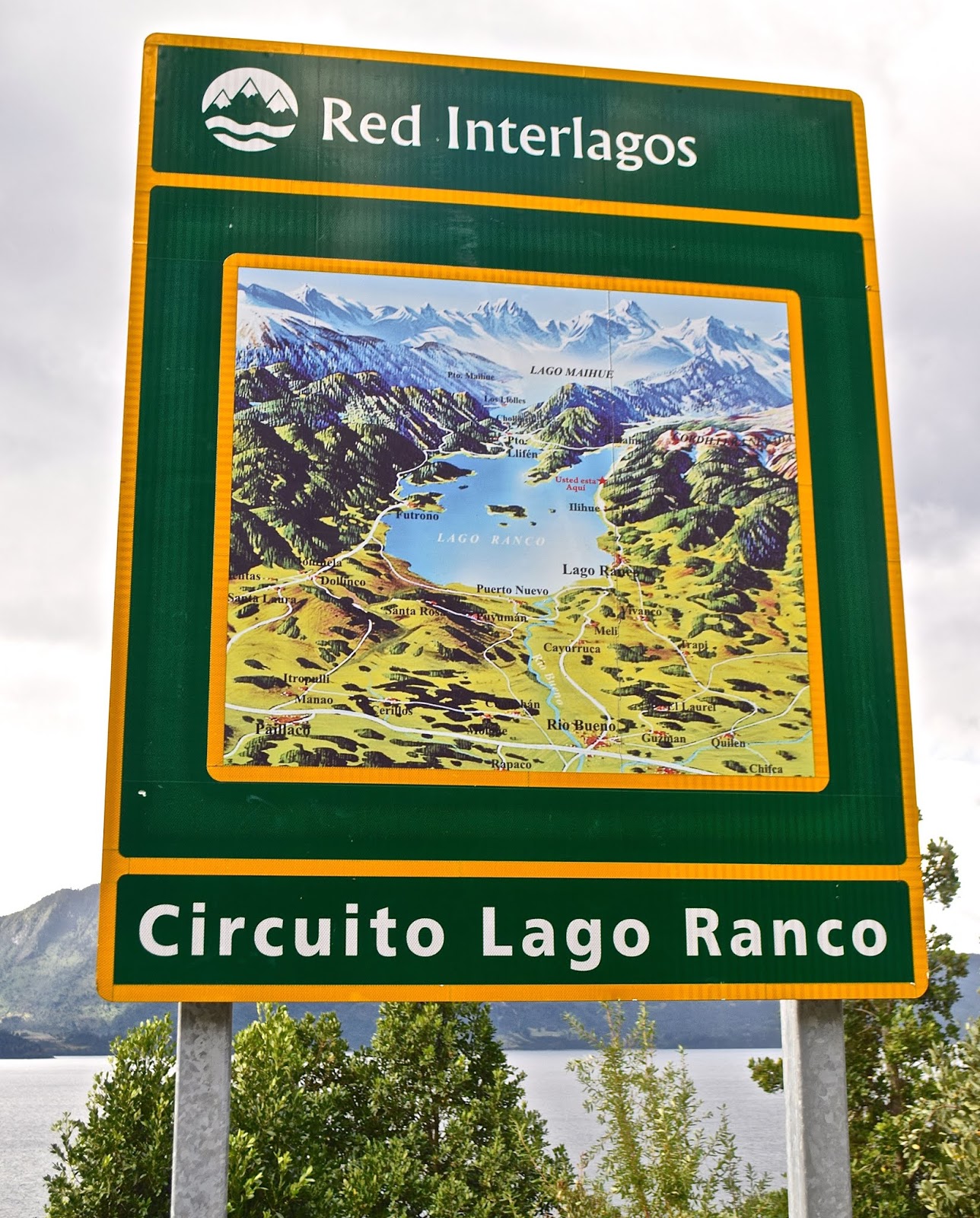
New highway signs mark the Red Interlagos.
Not so long ago, that wouldn’t have been possible but, in recent years, the Chilean government has linked and improved a series of roughly parallel easterly roads that provide a more scenic alternative along the lakes of the Andean front range. The Red Interlagos stretches from the town of Inspector Fernández, north of Temuco, south to the village of Puelo, southeast of Puerto Montt. I recommended an itinerary to my client and, when I next returned to Chile, I decided to follow the route—more or less—myself. It bears mention that the Interlagos is not a single highway, but a network of interconnected routes that pass through smaller towns and villages, not all of which are resorts, so there are multiple options.
Roadside frontage of the Hotel Awa
My client started in Puerto Varas and so did I, spending a couple nights in the new design Hotel Awa, a multi-story concrete, glass and girder structure on the city’s eastern outskirts. With views over Lago Llanquihue to the perfect cone of Volcán Osorno, it’s the area’s most technologically sophisticated hotel, but with rustic touches such as hiding the TV in an old steamer trunk at the foot of the bed. At night, I dined on truffled pork loin, complemented by a barley-based risotto from its own vegetable garden and garnished with a hazelnut sauce.
Grounds of the Museo Colonial Alemán, Frutillar
From Llanquihue’s south shore, there are two ways north, on the west side via Frutillar or the longer east side route via Ensenada. At the former, there’s the remarkable Teatro del Lago and the outstanding Museo Colonial Alemán, a tribute to German colonists that reminds me of in situ museums in Scandinavia.
A cycling event on the easterly route along Lago Llanquihue, beneath Volcán Osorno 
Puerto Octay, on Lago Llanquihue's north shore
I chose the longer route, which offers a detour up to the volcano’s ski area, which is open for hikers in summer, and then proceeded to picturesque Puerto Octay, a small north shore town with a metal-clad church and turreted houses that evoke Mitteleuropa. On Octay’s outskirts, my choice for the night is Hostal Zapato Amarillo, a Swiss-Chilean B&B with sod-roofed cabins, personalized attention, and fine dinners.
Hostal Zapato Amarillo is a cluster of sod-roofed guest rooms just outside Puerto Octay.
Hotel Termas de Puyehue is one of Patagonia's grand hotels.
For my client, though, I recommended continuing to Hotel Termas de Puyehue, a classic grand hotel at Parque Nacional Puyehue, about an hour north of Octay on the highway that runs from Villa La Angostura to Osorno. For visitors coming from Argentina, this sprawling hot springs hotel, with nearby hiking trails, makes an ideal overnight or multi-day stay in what may be the closest analogue to Bariloche’s Hotel Llao Llao. Along this highway, there’s still abundant evidence of the 2012 Puyehue-Cordón Caulle eruption that covered much of the area in ash.
Volcanic ash still covers parts of the shoulders along the highway between Argentina and Chile.
North of Entre Lagos, parts of the route are still unpaved but being improved.
I didn’t stay at the Puyehue this time, instead heading north through the town of Entre Lagos toward Lago Ranco, a lesser visited destination in the heart of Mapuche country. Along this segment, the Interlagos road signs say “Norpatagonia,” and, on a gravel surface with signs of improvement, muddy potholes splashed water onto my windshield. As I approached the south shore town of Lago Ranco, I could spot Isla Huapi, an offshore island inhabited almost exclusively by Mapuches.
The route around Lago Ranco is completely paved.
Here, in an area far more popular with Chileans than foreigners, I stopped for a sandwich before continuing east along a smooth paved road with plenty of scenic overlooks. The last time I had visited, a cable barge was the only means of crossing the Río Nilahue, but now modern bridges ease the route around the densely forested east side to the north shore town of Futrono. Here, almost opposite San Martín de los Andes, I spent the night at the Cabañas Nórdicas, a cluster of spacious and seemingly Scandinavian structures on a bluff overlooking the lake.
Sunset over Lago Ranco from my accommodations at Futrono
North of Futrono, the route’s a bit better trod, approaching the Ruta 5 town of Los Lagos but then veering northeast to Panguipulli, the entry point to a “Siete Lagos” route that resembles Argentina’s in Río Negro and Neuquén. Panguipulli fancies itself the "City of Roses" for its gardens at the east end of its namesake lake, but the area’s big attraction is its hot springs resorts. My client raved about the Zen-inspired Termas Geométricas—an isolated canyon of waterfalls, creeks and naturally heated pools linked by boardwalks near Coñaripe that’s open for day visits only—in the shadow of the fuming Volcán Villarrica.
The Termas Geométricas is a secluded hot springs venue south of Pucón.
Volcán Villarrica, as seen from Pucón, on the opposite side of Termas Geométricas
After a leisurely day at the Termas Geométricas, nearby accommodations options include the
Termas de Coñaripe—a hot springs hotel in its own right—and the town of Lican Ray, with its black sand beaches at Lago Calafquén. Termas Geométricas, though, gets many day-trippers from Pucón, the uber-resort city that’s just over the hill (mountains, that is) on Lago Villarrica. There, the place to stay is the hillside Hotel Antumalal, a Bauhaus-inspired masterpiece that, arguably, set the stage for Varas’s Awa. Still, there are many cheaper but still outstanding options here, and great hiking in spots like Parque Nacional VillarricaParque Nacional Huerquehue, and the Santuario Cañi, a private conservation effort aimed at protecting the area’s Araucaria forests.
Queen Elizabeth II and other big names have stayed at Pucón's Hotel Antumalal.
At Parque Nacional Huerquehue, the Sendero Quinchol leads to dense upland forests of Araucarias and southern beeches.
For visitors from Argentina, it’s easy to return by the Paso Mamuil Malal to Junín de los Andes and thence to Buenos Aires or back to Bariloche. The road goes on forever.

Friday, July 13, 2018

Finding the Forest For the (Monkey-Puzzle) Trees

New growth on an Araucaria branch, Parque Nacional Conguillío
In November of 1911, when John Muir climbed a ridge to camp among the “monkey-puzzle” forests of southern Chile, he marveled at “A glorious and novel sight, beyond all I had hoped for.” At the age 73, the legendary conservationist had sailed to South America, first exploring the Amazon and, after reaching Buenos Aires, he crossed the Andes in search of Araucaria araucana, the “monkey puzzle tree.”
Bark of a mature Araucaria tree
The present-day gateway to Fundo Ontario, where John Muir stayed in his search for the Araucaria
In Santiago—where even Juan Söhrens, director of the national botanical garden, had never seen the tree in the wild—Muir took a hint from a friend of the US ambassador and the train to the city of Victoria, just north of Temuco. Here, he made contact with the Smiths, a Canadian immigrant family, whose Fundo Ontario ranch was Muir’s gateway to the Andean foothills near what is today Parque Nacional Tolhuaca. It was here that sketched the forests and slept beneath the trees he’d come to observe—just as he did beneath the giant sequoias of California’s Sierra Nevada.
Parque Nacional Tolhuaca, with Araucaria trees in the right foreground and atop the ridge in the distance
Several times I’ve had the good fortune to see the area Muir visited, and several comparable areas on both sides of the Andes. The pewén, as it’s known in the indigenous Mapudungun language, has a narrow distribution between 37º20' and 40º20'S. In total, Araucaria forests cover less than 400 square kilometers, mostly in the Andean cordillera but with scattered stands in Chile’s coastal range.
A young ornamental Araucaria on the grounds of Oakland Technical High School
Where are the best places to see this distinctive tree, also known as the paraguas (umbrella tree)? It’s not uncommon as an ornamental—there’s one on the grounds of Oakland Technical High School, about five minutes from my California home—but Argentina and Chile are the Holy Grail. Following Muir’s trail toward Tolhuaca is one option, but access by public transportation is limited at best. Larger numbers see Parque Nacional Conguillío, to the southeast, which is more accessible from Temuco and the town of Melipeuco (though only by taxi).
A mature Araucaria forest at Parque Nacional Conguillío 
In terms of public transportation access, though, the best place to see the Araucariais the more southerly resort of Pucón. Two nearby national parks, Parque Nacional Villarrica and Parque Nacional Huerquehue, have frequent bus service. Personally, I prefer Huerquehue for easy access to hiking trails, dense pewén forests, and great panoramas that include the smoking, snow-topped Volcán Villarrica, which Spanish conquistador poet Alonso de Ercilla called the “great neighbor volcano.”
Araucarias on the Sendero Quinchol, Parque Nacional Huerquehue
On my most recent visit, though, I chose the Santuario Cañi, a private nature reserve that’s only 20 minutes out of town, and also easily accessible by public transport. I first hiked here in the 1990s as a guest of the non-profit Fundación Lahuén, on a sore ankle that caused me some difficulty. This time my joints were healthy, but the trail seemed even steeper than I remembered, and younger hikers were consistently passing me. At the end, though, I reached the plateau of Laguna Las Totoras, a marshy lake surrounded by monkey puzzle trees, but declined to climb to the El Mirador ridge. 
Hikers among the Araucarias in the Santuario Cañi
An Araucaria seedling has found growing space at Parque Nacional Nahuelbuta.
For my money, though, the best place to see the trees is Parque Nacional Nahuelbuta, in the coastal range near the city of Angol, where the trees even find growing spaces in cracks among its igneous outcrops. One of the best nights I ever spent was the campground here on Christmas Eve of 1998, when I had the entire park to myself. Nahuelbuta is scenic, with great hiking trails, but it doesn’t get many Chileans because it lacks water—there are no rivers or lakes suitable for swimming except outside park limits.
A panorama of the Araucaria forests at Parque Nacional Nahuelbuta
Along the trail at Argentina's Parque Nacional Lanín
I’ve barely mentioned Argentina, where the best site is Parque Nacional Lanín, across the Andes from Pucón, and easily reached from the cities of San Martín de los Andes and Junín de los Andes. It bears mention that the indigenous Pewenche—who take their name from the trees—gathered fallen forest nuts for their subsistence. I myself have eaten the toasted nuts and also consumed them in a pesto in a San Martín restaurant that is now, sadly, closed.
Pewén nuts on display at the Feria Masticar, an annual food fair in Buenos Aires

Thursday, April 23, 2015

Johnny Cash at Calbuco? Chile's Ring of Fire Erupts Again

In my academic field of geography, one of the specialties is natural hazards, a topic which was never central to my own research but which always attracted my attention. I grew up in the Pacific Northwest, where we felt the massive Alaska earthquake of 1964 and the cataclysmic eruption of Mt. St. Helens in 1980 (though I had moved away by then, a friend in Seattle, 96 miles to the north, told me that he thought the sound was someone slamming his front door very hard). I’ve lived through many earthquakes in the Bay Area, most notably the 1989 Loma Prieta (World Series) event.
And, of course, I’ve spent plenty of time in Chile, which has given me the opportunity to write about earthquakes, tsunamis, volcanic eruptions and floods (especially in recent weeks). Now, near the southern mainland city of Puerto Varas, one of my favorite Chilean destinations, the 2,003-meter (6,570-ft) Volcán Calbuco (pictured in the BBC video above) has upstaged the more northerly Volcán Villarrica, about which I wrote only recently.
In fact Calbuco (pictured above in quieter times) was one of my backup climbing choices after the recent closure of Villarrica to climbers, but I never actually made it Varas this last summer (though I passed nearby en route to Puerto Montt for the ferry to Puerto Natales). After Calbuco unexpectedly blew yesterday, I wrote my German friend Andreas La Rosé of Puerto Varas’s Casa Azul hostel to ask the effect there, and he seemed unconcerned: “Until now we have south wind and no rain. So no ash! In the moment everything is fine!”

That, however, was not the case for residents of Ensenada, a picturesque town at the east end of Lago Llanquihue. From Puerto Octay, on the north side of the lake, Armin and Nadia Dübendorfer of Hostal Zapato Amarillo wrote me this morning that “the volcano has settled down for the moment. The Ensenada area is seriously affected and was evacuated yesterday afternoon. Last night there were tremors and [a second] eruption was powerful, with thunder and lightning, the column of ash red with reflection from the lava.”

My friend Franz Schirmer, a Swiss-Chilean who owns Petrohué Lodge about 20 km east of Ensenada, sounded almost non-plussed: “Lots of noise, sand, ash and a spectacular lightning storm last night. Everything’s fine and now we’re working on removing the sand…” Interestingly, he referred me to his Twitter account, which included photos of him and his children at Calbuco’s crater two weeks ago; I wonder when – if ever - I’ll get that opportunity to do that hike.


Meanwhile, most of the ash seems headed eastward and, across the Argentine border, the residents of Bariloche are preparing themselves for an ashfall that could match that of the Cordón Caulle eruption of 2011. That could affect the upcoming ski season, as it did then, and air traffic to and from Argentine Patagonia.

Wednesday, March 4, 2015

Under the Volcano? The View from Pucón

At regular intervals for nearly 25 years now, at the Chilean resort of Pucón, I’ve been watching the steaming summit of Volcán Villarrica – what Spanish conquistador poet Alonso de Ercilla called its “great neighbor volcano” – without ever having climbed it. After arriving in Santiago at the end of January, I fully intended to do so, but a bout of bronchitis made it unlikely in the short term.
Even when I reached Pucón, in mid-February, I learned that Conaf (Chile’s national park service) had closed the mountain (pictured above) to climbers under an alerta amarilla (“yellow alert) as the lava-filled crater showed increased activity. Even after leaving town, I held out hopes of tackling the climb when I return later this month, but then the warning moved to alerta roja (“red alert”) and, in early hours of Tuesday morning, the mountain erupted spectacularly. I still may return to Pucón before leaving Chile, but the climb seems a long shot.
On the Monday, as authorities began to limit access to the national park, I wrote a friend in Pucón who thought the alerts suggested official alarmism, and I’ll quote him here:
“Sometimes there’s black smoke, at other times it ejects volcanic bombs, supposedly as far as a kilometer from the crater. As always, Conaf exaggerates and closes the park’s Rucapillán entrance [pictured above], while Onemi [the Interior Ministry’s emergency office] and Ovdas [Southern Andean Volcanic Observatory] say one should get no closer than two kilometers from the crater (the ski area is 3.5 kilometers away). In Pucón, we haven’t felt anything, no movement or noise, just occasional smoke with ashes and firelight at night. Some people are panicking and leaving, while others say it’s just normal.”

In fairness, past eruptions have affected the mountain’s south-side communities more than north-side Pucón, but the sudden eruption suggests that authorities were right to close the park. As I replied to my friend, “There’s always some idiot who’ll want to climb the mountain for a thrill,” and on Tuesday he had changed his tune a bit:

“Yes, [the eruption] was faster and more violent than we expected. I missed the beginning, but it was impressive at 3:30 a.m., then it diminished quickly. Except for those near the rivers with the possibility of lahars [mudflows], there was never really any danger.” Then, he added:

“Certainly some people will leave today, especially tourists. I think that, at the moment, the roads are still closed (possibility of floods), but I expect they’ll open soon. They closed the highways from Freire and Loncoche to [the more westerly city of Villarrica] to keep sightseers out. At 10 a.m., I’m going to the office.” Business as usual, then, for a travel agent.

A German friend, who lives closer to Villarrica and also works in the tourism industry, confirmed that “Everything is OK at our place. We are far enough away from the lava and we are in a green zone.” The last I heard, authorities had reduced the alert level to yellow, but it still seems unlikely that I’ll summit Rukapillán (to use the mountain’s indigenous Mapuche name) this year. And besides, slogging up loose volcanic debris is more tiring than crampons on the snow – much of which has now melted.


As to the title of this post, apologies to the late Malcolm Lowry, whose personal struggles were far more serious than my presently frustrated desire to scale the mountain.
Custom Search