Showing posts with label Roads. Show all posts

Saturday, October 6, 2018

Backroads Lakes of Chile

Chile’s Benjamín Subercaseaux famously described his country’s territory as “a crazy geography,” just as British author Sara Wheeler recounted her experiences there in Travels in a Thin Country between the Pacific Ocean and the high Andes. For much of the country’s history, travel has been a unidirectional venture, with few alternatives by sea, train or road—rather different from Argentina, where there’ve been multiple routes suitable for road trips.
Lago Llanquihue at Puerto Varas, the southern starting point for this road trip.
This occurred to late last year, when a New York reader wrote me about an upcoming literary trip to Chile—his book club takes it on the road—and asked me for recommendations for a trip between Puerto Varas and Pucón that would avoid the Ruta 5 freeway, the quickest (but least interesting) route between the two resorts.
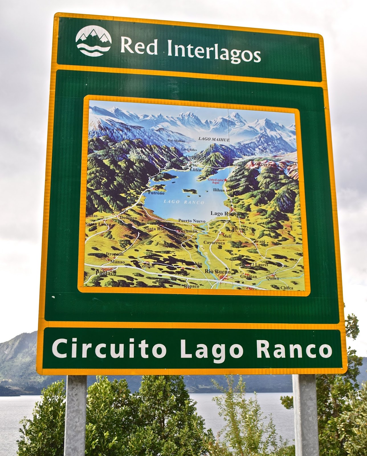
New highway signs mark the Red Interlagos.
Not so long ago, that wouldn’t have been possible but, in recent years, the Chilean government has linked and improved a series of roughly parallel easterly roads that provide a more scenic alternative along the lakes of the Andean front range. The Red Interlagos stretches from the town of Inspector Fernández, north of Temuco, south to the village of Puelo, southeast of Puerto Montt. I recommended an itinerary to my client and, when I next returned to Chile, I decided to follow the route—more or less—myself. It bears mention that the Interlagos is not a single highway, but a network of interconnected routes that pass through smaller towns and villages, not all of which are resorts, so there are multiple options.
Roadside frontage of the Hotel Awa
My client started in Puerto Varas and so did I, spending a couple nights in the new design Hotel Awa, a multi-story concrete, glass and girder structure on the city’s eastern outskirts. With views over Lago Llanquihue to the perfect cone of Volcán Osorno, it’s the area’s most technologically sophisticated hotel, but with rustic touches such as hiding the TV in an old steamer trunk at the foot of the bed. At night, I dined on truffled pork loin, complemented by a barley-based risotto from its own vegetable garden and garnished with a hazelnut sauce.
Grounds of the Museo Colonial Alemán, Frutillar
From Llanquihue’s south shore, there are two ways north, on the west side via Frutillar or the longer east side route via Ensenada. At the former, there’s the remarkable Teatro del Lago and the outstanding Museo Colonial Alemán, a tribute to German colonists that reminds me of in situ museums in Scandinavia.
A cycling event on the easterly route along Lago Llanquihue, beneath Volcán Osorno 
Puerto Octay, on Lago Llanquihue's north shore
I chose the longer route, which offers a detour up to the volcano’s ski area, which is open for hikers in summer, and then proceeded to picturesque Puerto Octay, a small north shore town with a metal-clad church and turreted houses that evoke Mitteleuropa. On Octay’s outskirts, my choice for the night is Hostal Zapato Amarillo, a Swiss-Chilean B&B with sod-roofed cabins, personalized attention, and fine dinners.
Hostal Zapato Amarillo is a cluster of sod-roofed guest rooms just outside Puerto Octay.
Hotel Termas de Puyehue is one of Patagonia's grand hotels.
For my client, though, I recommended continuing to Hotel Termas de Puyehue, a classic grand hotel at Parque Nacional Puyehue, about an hour north of Octay on the highway that runs from Villa La Angostura to Osorno. For visitors coming from Argentina, this sprawling hot springs hotel, with nearby hiking trails, makes an ideal overnight or multi-day stay in what may be the closest analogue to Bariloche’s Hotel Llao Llao. Along this highway, there’s still abundant evidence of the 2012 Puyehue-Cordón Caulle eruption that covered much of the area in ash.
Volcanic ash still covers parts of the shoulders along the highway between Argentina and Chile.
North of Entre Lagos, parts of the route are still unpaved but being improved.
I didn’t stay at the Puyehue this time, instead heading north through the town of Entre Lagos toward Lago Ranco, a lesser visited destination in the heart of Mapuche country. Along this segment, the Interlagos road signs say “Norpatagonia,” and, on a gravel surface with signs of improvement, muddy potholes splashed water onto my windshield. As I approached the south shore town of Lago Ranco, I could spot Isla Huapi, an offshore island inhabited almost exclusively by Mapuches.
The route around Lago Ranco is completely paved.
Here, in an area far more popular with Chileans than foreigners, I stopped for a sandwich before continuing east along a smooth paved road with plenty of scenic overlooks. The last time I had visited, a cable barge was the only means of crossing the Río Nilahue, but now modern bridges ease the route around the densely forested east side to the north shore town of Futrono. Here, almost opposite San Martín de los Andes, I spent the night at the Cabañas Nórdicas, a cluster of spacious and seemingly Scandinavian structures on a bluff overlooking the lake.
Sunset over Lago Ranco from my accommodations at Futrono
North of Futrono, the route’s a bit better trod, approaching the Ruta 5 town of Los Lagos but then veering northeast to Panguipulli, the entry point to a “Siete Lagos” route that resembles Argentina’s in Río Negro and Neuquén. Panguipulli fancies itself the "City of Roses" for its gardens at the east end of its namesake lake, but the area’s big attraction is its hot springs resorts. My client raved about the Zen-inspired Termas Geométricas—an isolated canyon of waterfalls, creeks and naturally heated pools linked by boardwalks near Coñaripe that’s open for day visits only—in the shadow of the fuming Volcán Villarrica.
The Termas Geométricas is a secluded hot springs venue south of Pucón.
Volcán Villarrica, as seen from Pucón, on the opposite side of Termas Geométricas
After a leisurely day at the Termas Geométricas, nearby accommodations options include the
Termas de Coñaripe—a hot springs hotel in its own right—and the town of Lican Ray, with its black sand beaches at Lago Calafquén. Termas Geométricas, though, gets many day-trippers from Pucón, the uber-resort city that’s just over the hill (mountains, that is) on Lago Villarrica. There, the place to stay is the hillside Hotel Antumalal, a Bauhaus-inspired masterpiece that, arguably, set the stage for Varas’s Awa. Still, there are many cheaper but still outstanding options here, and great hiking in spots like Parque Nacional Villarrica, Parque Nacional Huerquehue, and the Santuario Cañi, a private conservation effort aimed at protecting the area’s Araucaria forests.
Queen Elizabeth II and other big names have stayed at Pucón's Hotel Antumalal.
At Parque Nacional Huerquehue, the Sendero Quinchol leads to dense upland forests of Araucarias and southern beeches.
For visitors from Argentina, it’s easy to return by the Paso Mamuil Malal to Junín de los Andes and thence to Buenos Aires or back to Bariloche. The road goes on forever.

Sunday, August 18, 2013

A Coastal Road Trip, From Canada to Chile?


Often, on this blog and elsewhere, I’ve pointed out that the west coast of South America is a mirror image of its North American counterpart, with vast deserts comparable to those of Baja California, a Mediterranean heartland resembling California, and mid-latitude forests and fjords in higher latitudes.

One of the comparisons I make, in the course of writing and lecturing, is between British Columbia’s Vancouver Island and Chile’s Isla Grande de Chiloé. Superficially, the comparison is obvious – they’re two large islands slightly separated from the continent, by the Strait of Georgia and the Canal de Chacao, respectively (though Vancouver Island is three times larger).
Both are lush and forested, with temperate rain forests and extensive hiking trails, but they have one thing in common that I learned only recently. My Moon colleague David Stanley, who covers the South Pacific but also overlaps with me in covering Rapa Nui (Easter Island), informs me the village of Lund (pictured above) is (in the words of a local website) “the northern terminus of Highway 101, the Pacific Coastal Highway, a 15,200 km highway along the Pacific Coast extending from Canada to Chile” (photograph courtesy of David Stanley).
I have never been to Lund (named after the Swedish city), though I have been to more southerly parts of Vancouver Island. I have, however, been many times to the port of Quellón (pictured above), the route’s ostensible southern terminus, on the Isla Grande. I had, however, never heard of the “Pacific Coastal Route” as any sort of unified entity – in fact, US 101, which runs through Washington, Oregon and California, often heads inland while California’s State Highway 1 almost invariably sticks to the coast.

To the south, Mexico’s Carretera Federal No. 1 runs the length of the Baja California peninsula, but is not always coastal and, where it is coastal, it’s not always on the Pacific. In the rest of Mexico and Central America, the Pan-American Highway often approaches the coast but, in the words of journalist Jake Silverstein, it’s “a system so vast, so incomplete and so incomprehensible it is not so much a road as it is the idea of Pan-Americanism itself.”

There is, of course, no highway through Panama’s Darien Gap, and roads rarely follow the lush tropical lands along the Pacific coasts of Colombia and Ecuador, where most of the people live in the highlands. Peru and northern Chile are a different matter, but in Chile’s Mediterranean heartland and southern lakes region the main highways bypass the shoreline for the central valley.

I’ve never been to Lund and, though I’ll probably revisit Quellón later this year, I’ll still find it hard to think of it as the end point of any unified route – especially since there are several other ferry crossings I’ve not yet mentioned, including one that continues south to Chile’s own Carretera Austral, arguably the best road trip in all of South America.

Wednesday, May 30, 2012

For Whom the Toll Beeps (Or, Playing TAG in Santiago)

In California, where I spend most of the year, toll roads are anathema. We do have plenty of bridges that collect tolls, but there’s a reason that many of our highways are, for better or worse, misleadingly called “freeways” (we pay for them but, except for the bridges, we don’t usually pay directly out of pocket to use them).
It’s different in Chile, where the Panamericana from La Serena south to Puerto Montt – a distance of roughly 1,500 km – has 15 toll plazas that exact a total of nearly 35,000 pesos (about US$70) from anybody who drives the distance. That’s not counting the cost of driving through Santiago, which is a little more complicated.

That’s because Santiago has its own electronic toll system that requires anyone who drives those roads to pay a distance-based rate that varies according to the time of day, with the morning and evening rush hours the costliest. Santiago drivers have gotten accustomed to the so-called TAG or Televía system and most, like me, have an electronic transponder that registers the tolls automatically. It can be confusing, though, to drivers from other parts of the country and especially those from outside the country, such as Argentines who frequently travel to Chile.

The TAG is not obligatory, but paying the toll is, even if you don’t have a transponder. Relatively few people outside Santiago do, and some of them go out of their way, when visiting the capital, to use surface streets rather than the limited access highways. A friend of mine from La Serena tried this when picking up someone at the international airport but, eventually, had to pay a fine when he found the alternative route too complicated and couldn’t avoid the toll road. Cameras record the license plates of every vehicle, so enforcement is simple if sometimes slow.
For those who need to drive in the capital, there is an alternative: approaching the city limits, they can purchase a pase diario (daily pass) for 4800 pesos (a little less than US$10) at any roadside Copec Pronto convenience store. Those who fail to do so draw a fine but, even then, it’s possible to purchase the pass retroactively up to 20 days later; after three days, the cost increases to 6900 pesos (about US$14). For overseas visitors, it’s worth adding that cars rented in the capital will have a transponder to record the tolls automatically (to be incorporated in the rental cost). Those rented elsewhere may not have one, though, and you will be directly responsible for the toll.


While Chilean vehicles may not be able to escape the Santiago tolls, foreign vehicles might. It wouldn’t surprise me if many Argentine drivers, either unaware or evasive, use the city’s highways without paying. If they get stopped by the Carabineros police, though, they could be in trouble.

The Panamericana is not Chile’s only toll road. There are others from Santiago to the port cities of Valparaiso and San Antonio, and between Chillán and Concepción. There’s also a new four-lane divided segment connecting the Atacama desert cities of Vallenar, Copiapó, and Caldera.

Let’s Choose (Moon) Patagonia! (Update)
To date, I’ve had only one correct answer on my geography quiz from the previous post, asking readers to name the Chilean volcano that affected travel to Argentine Patagonia prior to the 2011 eruption of Puyehue. Because of that, I’ll add a couple clues – the eruption in question took place in 2008, and required the evacuation of its namesake village.
If nobody else comes up with a correct answer by the weekend, I’ll postpone giving away the second copy of Moon Patagonia. Please send your answer to southerncone (at) mac.com, and not to the comment box.

Tuesday, April 24, 2012

Getting Around Rapa Nui

Because I own a car in Chile, I rarely find it necessary to rent one either here or in Argentina. The main exception is Rapa Nui (Easter Island), as it’s hardly practical to ship my own vehicle more than 3,700 km – that’s the distance from the northern city of Caldera, the nearest point on the Chilean mainland - from the port of Valparaíso on a quarterly supply ship.
Of course, Rapa Nui isn’t very big, only about 171 sq km (roughly 66 square miles), but it’s just big enough that walking around the village of Hanga Roa and getting out to see its monumental archaeological sites is more time-consuming than most visitors expect. Given that I now spend most of my visits updating practical information in town, rather than seeing the sights per se, I rent a car when, as last Saturday, I take a semi-sightseeing day.
For getting around Hanga Roa, many hotels have loaner or rental bikes, and several agencies along the main commercial street of Atamu Tekena offer rentals as well. Strong mountain bikers can probably handle the main sightseeing loop from Hanga Roa east to Rano Raraku (pictured at top) and Ahu Tongariki, then northwest to Playa Anakena (pictured above) and back in a day, but should get an early start – there’s a lot to see. The climbs on that route are mostly gradual, but it’s imperative to carry water (though water may be available for sale at Rano Raraku and Anakena).
Cycling to the crater of Rano Kau (pictured above) and the Orongo ceremonial village (pictured below), just south of the village, means a steep climb from sea level to more than 400 meters (but a breezy ride down). I’ve usually taken a taxi (about US$6) there, and walked back along a footpath that offers spectacular ocean views and passes some seaside lava caves that one might otherwise miss.
This time, to do the loop described above, I rented a car from Insular Rent A Car (pictured below) which, like other agencies in the village, also offers motorcycles and quadricycles. The first vehicle they gave me, though, had what felt like a dangerous shimmy as I left town, and I returned it slowly and exchanged it for another, better one. The explanation I got was that no place on the island is equipped to do front end alignments; fortunately, the second car was in better shape. It’s worth noting that no 4WD vehicles are available or even necessary – the main roads are not bad – but high clearance is still a good idea.
Renting a car for the day cost me 30,000 pesos, about US$60 at the current exchange rate. In fact, the 24-hour rate was 35,000 pesos (about US$70), but I managed to negotiate the eight-hour rate for a period that took me from 10:30 a.m. to 8 p.m. This is possible in face-to-face negotiation, especially if you suggest you might go to the agency across the street, but if you call to have a vehicle delivered to your hotel, there’s not much room for discussion.

There’s one big caveat about renting a car here – there is no such thing as collision insurance on the island so, if you wreck a car, you’re on your own. Agencies require a credit card deposit slip that they’ll tear up if you return the car in reasonable shape – they don’t inspect for dents the way, say, Hertz might. Most cars here have a few dings, and plenty of those are due to the feral horses that have virtually free run over the island.

Saturday, March 10, 2012

Adventures in Bureaucracy

While I have a second home in Buenos Aires, my “mobile base” while updating my Moon Handbooks is Chile. That’s partly because the capital city of Santiago is more logistically convenient to my California home, but mostly because I own a car here. From Santiago, I use my aging but reliable 1996 Nissan Terrano (equivalent to a Pathfinder elsewhere) for overland research on Chile, Argentina and Patagonia (only once have I taken it to Buenos Aires, where I don’t need a car, and I’d prefer not to repeat the experience).
On occasion, readers ask me about shipping a car to South America and my reply is that, for a period of four months or longer, it can make more sense to buy a vehicle in Chile. That’s partly because there’s a good fleet of used cars here and the process is relatively simple but, no less importantly, Chile places no obstacles on non-resident foreigners leaving the country with a Chilean vehicle. That’s in stark contrast with Argentina, which considers every car a so-called vehículo nacional, though it’s private property. A non-resident foreigner can purchase a car there, but will encounter problems trying take it out of the country. Rental cars, of course, are an exception.

One of my favorite anecdotes in this regard is that of a Swiss family I met in Puerto Octay, Chile, who had purchased a 4WD vehicle in Bariloche. When they first tried to cross the border in hope of driving Chile’s Carretera Austral, Argentine customs officials refused them passage because, they insisted, it was a vehículo nacional that no non-resident could take out of the country. Was their trip over before it started?

Returning to Bariloche, they contacted the vehicle’s seller and, at his suggestion, they obtained a power of attorney over the vehicle in favor of his brother. The brother then accompanied them to the border, drove it across and, when they reached the city of Osorno, they bought him a bus ticket back to Bariloche. They then proceeded down the Carretera Austral while knowing, however, that they would have to buy the brother another bus ticket to re-enter the vehicle into Argentina. In Chile, fortunately, such evasions are unnecessary.

While Chile’s bureaucracy may be more reasonable than Argentina’s, and has the additional virtue of never soliciting bribes, it can occasionally be confusing for those of us who’ve not grown up in it. I found that out this week while renewing the Terrano’s annual permiso de circular (license fee) and attempting to replace its sello verde, the green windshield sticker that designates vehicles with catalytic converters. Older vehicles without this sticker may be grounded one day a week on  “spare the air” days in Santiago, which are most common at this time of year.
The first step in renewing the permiso de circular is a revisión técnica, an inspection at a privately run but state-licensed test facility (such as the one pictured above). Compared with the biannual smog inspection that we have in California, the Chilean version is far more demanding – not only do the inspectors measure pollutants coming out of the tailpipe, but they also assess the vehicle’s roadworthiness. This means checking the brakes, monitoring the headlights (including their accuracy), taillights and turn signals, and even measuring the tread on the tires – if the tread falls below a certain thickness, the vehicle fails the inspection, and the owner needs to replace the tire(s) before getting the final OK. One advantage of this system is that you can be pretty sure that any vehicle on the street, no matter how cosmetically dilapidated it might look, is indeed roadworthy.

The Terrano readily passed the inspection, so it could get a new permiso de circular, but the sello verde was a different matter. Years of exposure to the sun, plus the need to remove it from a cracked windshield and stick it on the replacement, had left it singed black, in tatters and virtually unreadable. Nobody could tell me precisely where or how to replace the sello verde, but my mechanic suggested I go the Registro Civil, the civil registry in downtown Santiago where I had originally transferred the title. An information officer there politely informed me that, unless I was looking to establish residence in the country, perhaps I should ask at the Ministerio de Transporte, the transport ministry a couple blocks away.
At the ministry, an equally polite and helpful woman told me I should contact the Dirección de Tránsito in the comuna (borough) of Las Condes, where I got my last permiso. In Chile, individual boroughs issue these permissions and, every March, there’s an intense competition among them to register as many vehicles as possible because that's where they get their tax revenues (pictured above is a typical outdoor registration site, of the sort that's common around town).

Before heading cross-town to Las Condes, though, I decided to phone to verify the information. In fact, a woman there told me, I had to replace the sello verde where the original permiso de circular was granted and that, according to her, was the easterly borough of La Reina. To be certain, I phoned La Reina’s Dirección de Tránsito and was told that, in fact, the original permiso de circular came from the southerly borough of San Miguel, where I had never been.

Consequently, I phoned San Miguel’s Dirección de Tránsito where, the woman who answered told me, I should replace the sello verde where I had the last permiso de circular - in Las Condes. I was on a bureaucratic merry-go-round, and "circular" sure seemed to be the appropriate word. How much farther round would I have to go?
After explaining this, though, she said that if I were willing to support San Miguel with my tax pesos, she would see to it that I could also replace my sello verde. Yesterday morning, after breakfast, I made my way to San Miguel – which turned out to be a pleasant middle-class borough studded with new high-rise apartment buildings (pictured above) – and arranged everything with minimal delay. I’m nearly ready to hit the road.

Wednesday, January 25, 2012

Book Review: The Practical Nomad

Ever since I first visited Latin America, with a spur-of-the-moment train ride from Mexicali to Mazatlán nearly 40 years ago, I have preferred to travel independently and – with the exception of a few necessarily fixed cruise ship itineraries - I’d sooner wing it. Even now, as my Moon Handbooks and other writings include suggested itineraries for those who must fit their travels into fixed periods from a week to a month or more, my own itineraries remain flexible.
Of course, I do travel differently than I did in the days before I had a family, a mortgage, and other responsibilities. Nearly all my travels now have to do with updating my Moon Handbooks to Argentina, Buenos Aires, Chile, and Patagonia, and this differs greatly from traveling “for pleasure.” Given that, almost every year, I spend four to five months in southernmost South America, when I return to my home in California, I don’t feel like traveling much farther than around the block, whenever my dog needs to go out. Even less do I feel like devoting a month or more to, say, take the Trans-Siberian Railway across Asia.

That’s not to say my travel is not pleasurable – I greatly enjoy revisiting the sights of the Southern Cone countries, and seeing people I have grown to know over more than two decades as a guidebook and travel writer. I enjoy good meals and fine wines, but at the same time I’m aware this is now work. While a first-time visitor to Buenos Aires needs to find one hotel, I need to know dozens or more; where the one-timer needs to know when the next bus leaves from Bariloche to El Bolsón, I need to know them all. Guidebook writing means long days and much of the product is inevitably formulaic – there’s only so much you can do with bus schedules.

I don’t regret this change in the way I travel but, at the same time, I do miss the spontaneity with which I once backpacked down the “Gringo Trail” all the way to Tierra del Fuego and through Western Europe in the days before the Berlin Wall came down. Another person who’s adapted to the times is my travel-writing colleague Edward Hasbrouck, probably the best-traveled person I know, who’s just released a new fifth edition of The Practical Nomad: How to Travel Around the World.

The Practical Nomad is exactly what it says: a nuts-and-bolts manual on traveling abroad – not necessarily literally “around the world” - for extended periods of time. It is not destination-oriented; rather, it offers suggestions on how to get the best out of whatever destination you choose. I recall that, after renting our apartment in Buenos Aires, he and his companion Ruth Radetzky found plenty to see and do in muggy subtropical Posadas - a city that foreign air travelers rarely even see and most overlanders visit only long enough to change buses for Iguazú falls. To quote a phrase from the classic People’s Guide to Mexico, “Wherever you go, there you are.”

That said, it The Practical Nomad offers informed tips that, given Edward’s background as a professional travel agent and right-to-travel activist, are far more knowledgeable that the scuttlebutt rumors I used to get from other travelers whose paths I crossed. They are light years better than any crowd-sourced information on the Internet, even though I might quibble with some of his details. I agree with him, for instance, that the countryside of Argentina, Chile and Uruguay is best seen by rental car, but would emphasize that Chilean roads, particularly, are fast reaching North American standards – especially given the fact that Chile is investing in its infrastructure, even as the United States is letting its highways go to pot(holes).

The Practical Nomad, though, focuses on topics such as getting time off for foreign travel and financing it, flights and other transportation options, the bureaucracy of documents, visas and border crossings, and especially tech suggestions. Edward also writes the informative blog of the same name, The Practical Nomad, which stresses of freedom-of-travel issues but also provides perspective on topics such as The Amazing Race “reality” TV show.

Monday, June 6, 2011

Ash Across the Andes: Chile's Volcán Puyehue Erupts


In 1979, when I first visited Chile, one of my most memorable excursions was an overnight trek to the slopes of Volcán Puyehue, a stratovolcano that, as part of the Puyehue-Cordón Caulle Volcanic Complex, produced a massive 1960 eruption shortly after the historic Valdivia earthquake (at 9.5 on the Richter scale, the most powerful ever recorded). Continuing for two months, that eruption (depicted in the NOAA photograph above) left a landscape that, despite a marine west coast climate comparable to Seattle or Portland, was no less barren than the Atacama Desert.

At a time when Chile received few foreign visitors, I saw nobody else even along the trail's wooded lower slopes, slept in a comfortable national park shelter, and soaked in rustic thermal baths, all the while photographing sights such as the geometric fumaroles and massive lava flows left by the eruption nearly two decades earlier. Since I did it, the Puyehue trek has acquired a certain popularity for its scenic grandeur and its easy accessibility on the international highway from Osorno to the Argentine lakes district resorts of Villa La Angostura and San Carlos de Bariloche.

At the moment, though, this route is closed, and not just because of early winter snowstorms. On Saturday, the Córdon Caulle erupted with pumice and ashfalls that forced the evacuation of some 3,500 people, and closed the highway between Chile and Argentina (some footage on Chilean TV showed policemen hefting stones of lightweight pumice now scattered along the road over the Andes). Guests at the historic Hotel Termas de Puyehue, a classic hot springs resort within Parque Nacional Puyehue, were among the evacuees.

According to MercoPress, the ashfall has also left Bariloche beneath a film of gray; city residents were advised to stockpile water and wear surgical masks if they needed to go out, to avoid breathing the ash. Parts of Argentina’s Ruta 40 were 30 centimeters (about 12 inches) deep in ash, making driving inadvisable. It also obliged Argentine authorities to suspend flights and close airports at Bariloche, San Martín de los Andes, Neuquén, Esquel and even the Atlantic coast city of Trelew.

Originally, the column of steam and ash reached an altitude of ten kilometers (roughly 30,000 feet) but, as of Sunday, it had subsided. Presuming it continues to subside, the economic disruption should be minimal but, if it continues, it could have a high cost. After the Libertadores pass between Santiago and Mendoza, the Cardenal Samoré pass is the second-busiest border crossing between the two countries, both for commercial and tourist traffic.

Many Chileans spend the weekend across the border but, more importantly for Bariloche, Villa La Angostura, San Martín de los Andes and Esquel, ski season is about to begin. If flights from Buenos Aires and Brazil can’t land anywhere in northern Argentine Patagonia, it won’t matter how much snow falls at Cerro Catedral, Cerro Bayo, Chapelco and La Hoya.

Help Reactivate the Economy, with Southern Cone Travel
If you have found this article informative, please consider clicking on one or more of the AdSense links that accompany it - always presuming, of course, that it’s a product or service that interests you.

Tuesday, May 17, 2011

The Scrap Metal Capital of the Americas

For a decade-plus now, I have owned a Nissan Terrano, a 4WD vehicle with which I explore southern South America while updating my Moon Handbooks to Argentina, Chile, Patagonia and Buenos Aires. Every November, when I return to Santiago, one of my first chores is to take it for the revisión técnica, the annual vehicle inspection that determines whether or not a Chilean car is roadworthy. This is a serious inspection, even more so than in California, where private vehicles must undergo a smog check every other year. In Chile, that smog check is annual, but that’s not everything - the technicians there also check your front-end alignment, the tread of your tires, brakes, the emergency brake, and even the alignment of your headlights. If any one of these is not up to snuff, the vehicle fails the inspection and you have two weeks to correct any problems. For that reason alone, accidents due to equipment failures are rare on Chilean highways. In principle Argentina has a similar system but, in reality, there are probably hundreds of thousands of unsafe vehicles that, at the same time, pollute the country’s skies. Once, near the city of Mendoza, I recall a rattletrap Fiat on the freeway with only a single parking operative parking light - no headlights or taillights at all - that was barely capable of 50 km per hour (about 30 km per hour). On a road where most vehicles were traveling at least twice that speed, the potential for a pileup with a tiny car that was barely visible was inordinately high. This was not an exception, though. In no other country have I seen so many obviously unroadworthy cars. When I once asked an Argentine policeman whether these cars ever get ticketed, he told me “no” - despite the frequent checkpoints along the highways, they would rarely consider pulling even a flagrantly unsafe vehicle off the road. That’s ostensibly because of their interest of maintaining “social peace” - most such vehicles belong to poorer people who need them for errands or work. The less charitable among us, though, might observe that the drivers of such vehicles are unlikely to have extra money to bribe the cops to look the other way. Neither “social peace” nor bribery is an issue in Chile, however.
Lola at a Chilean mechanic's, 1992
Twenty-some years ago, when I wrote my first-ever guidebook to Argentina, Uruguay, and Paraguay, I traveled the Southern Cone highways and backroads in a 1969 Peugeot T4B panel truck that my wife nicknamed “Lola.” Purchased indirectly from my late father-in-law, Lola was a wreck waiting to happen and, in the course of my travels, I seemed to meet every mechanic in the Southern Cone countries just to keep it going. After doing another book on Chile the following year, we sold the car in their Buenos Aires province hometown of Olavarría and, I understand, it’s now doing duty on a ranch - its roadworthiness was always questionable but now, at least it’s one vehicle that won’t cause an accident. I photographed the Ford pickup at the top of this entry in the city of Salta at what, amazingly, is a detailing shop - like Lola, it’s a chata, a word that Argentines apply to any utilitarian pickup (in Mexican slang, the same word has some off-color meanings) . Its etymology is unclear, but it’s superficially close, at least, to chatarra, a word best translated as “scrap metal.” There are chatas and chatarra everywhere in Argentina, but the two really come together in El Bolsón, the northern Patagonian town renowned for its Plaza Pagano street fair (pictured below). In the parking lot behind the plaza is an extraordinary assortment of junk cars - both chatas and chatarra - that mostly, fortunately, are incapable of getting far beyond the city limits. If you have found this article informative, please consider clicking on one or more of the AdSense links that accompany it - always presuming, of course, that it's a product or service that interests you.
Custom Search